CEES has a long history of involvement in a number of diverse water quality monitoring and research efforts in watersheds across the State of Indiana with many of these efforts having been focused in the Upper White River Watershed (UWRW), located right here in central Indiana.
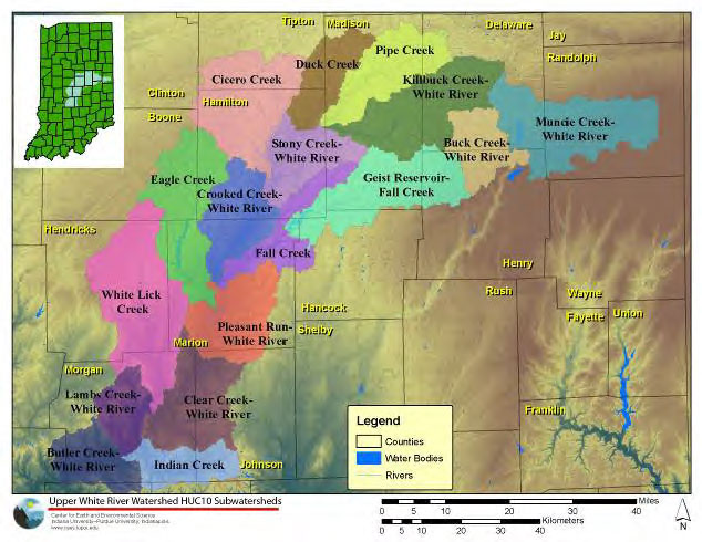
The UWRW consists of seventeen smaller subwatersheds and includes more than 2,180 miles of streams and a drainage area covering approximately 2,718 square miles including parts of sixteen central Indiana counties. The UWRW feeds four drinking water supply reservoirs including Geist Reservoir, Morse Reservoir, Prairie Creek Reservoir, and Eagle Creek Reservoir. In addition to providing drinking water to the residents of central Indiana, these four reservoirs are also important recreational amenities within the watershed.
While a majority of the land within the UWRW is still utilized for agricultural purposes, primarily corn and soybean production, the watershed is also experiencing rapid expansion of urban and suburban areas as it houses a number of Indiana’s largest cities including the state capital, Indianapolis. In fact, according to U.S. Census Bureau 2010 Census, more than 30% of the State of Indiana resides in the twelve of the sixteen counties that make up the vast majority of UWRW, and house the major cities within its borders, making it particularly susceptible to anthropogenic influences related to both agricultural practices as well as the effects of urbanization.
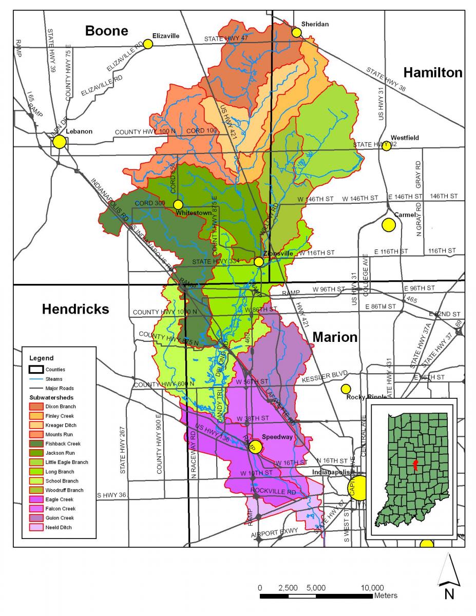
Due to its importance as a direct input into a drinking water reservoir for the City of Indianapolis, perhaps no piece of the UWRW has received more attention than Eagle Creek Watershed (ECW), one of the seventeen subwatersheds that makeup the UWRW. Eagle Creek Watershed is located in central Indiana approximately ten miles northwest of downtown Indianapolis and is made up of ten smaller subwatersheds. The watershed as a whole is relatively flat and has a drainage area of approximately 162 square miles upstream of the Eagle Creek Reservoir dam.
Eagle Creek Reservoir, which is used as both a public drinking water supply and a flood control reservoir for the City of Indianapolis, is located completely within Marion County, while the rest of Eagle Creek Watershed runs through parts of Marion, Hendricks, Boone, and Hamilton counties. Like the UWRW as a whole, the dominant land use in Eagle Creek Watershed is agriculture with some portions of the watershed, particularly those close to the reservoir, undergoing urbanization.
Many of the water quality concerns investigated in the Upper White and Eagle Creek Watersheds began when potentially hazardous water quality issues such as elevated nutrient and pollutant concentrations and algal blooms were first expressed and identified downstream in Eagle Creek Reservoir. Subsequent studies illustrated just how widespread and complex many of these water quality issues are and have since led to continued research efforts focused on understanding the linkages between lake and stream ecology, historical and evolving land use practices, and their relationship to water quality concerns in the watershed as a whole.
To better quantify the effects of agricultural practices on water quality and quantity, the Natural Resource Conservation Service (NRCS) has developed a new national program, Edge-of-Field (EOF) sampling. In this program the NRCS contracts with farmers to directly monitor water quality in their fields. The first EOF project in Indiana is at Starkey Farms in the School Branch watershed (a subwatershed of the Eagle Creek watershed). CEES is excited to collaborate with Starkey Farms and the NRCS in this project. For the next 6 years (2014-2020), CEES affiliated scientists and students will be monitoring water quality at Starkey Farms. This is a major step towards sustainable water resources in the Eastern Corn Belt, and CEES is proud to be part of it. Please check back regularly for more details, or contact us for more information.
CEES continues to work with community stakeholder groups, such as the Upper White River Watershed Alliance and the Eagle Creek Watershed Alliance, to facilitate watershed management programs with the ultimate goals of improving water quality, increasing public awareness of watershed quality issues, and encouraging stewardship of watershed resources. In cooperation with these groups, CEES provides research and infrastructure support to area environmental consulting firms, nonprofit groups, and local, state and federal government agencies. With a developed a network of experimental sites located throughout central Indiana, CEES continues to evaluate approaches to the restoration of river and wetland ecosystems and strategies for the improvment of water quality.
Past projects in these watersheds have included:
Eagle Creek Watershed Management Plan
2005
Aided in development of the Eagle Creek Watershed Management Plan
2007 - 2009
Aided in 3-year, Phase 1, U.S. Environmental Protection Agency Clean Water Act 319 grant under an assistance agreement with the Indiana Department of Environmental Management to implement the Eagle Creek Watershed Management Plan including monthly sampling water quality monitoring at eleven sites throughout the Eagle Creek Watershed
2009 - 2012
Aided in 3-year, Phase 2, U.S. Environmental Protection Agency Clean Water Act 319 grant under an assistance agreement with the Indiana Department of Environmental Management to implement the Eagle Creek Watershed Management Plan including monthly sampling water quality monitoring at eleven sites throughout the Eagle Creek Watershed
Aquisafe
2007 - present
Contributing to a group of efforts known collectively as the AQUISAFE project, an international collaboration between IU Indianapolis, Veolia Water, and Kompetenzzentrum Wasser, Berlin including:
- Collection of water samples in the Upper White River and Eagle Creek Watersheds for an analysis of the nature, occurrence, and risk of source water contamination by substances and metabolites issued from land use in rural and semirural areas including a suite of nutrients, agrochemicals, pathogens, pharmaceuticals, and emerging contaminants and an analysis of existing tools to diagnose the contaminants’ origin, load, and repartition to assess the effects of adapted controlled measures
- Reviews of the effectiveness of riparian zones and constructed wetlands as tools for contaminant mitigation
- Installation and investigation of a bioswale designed to capture and improve the water quality of direct flow from an agricultural tile drain before discharging into the headwaters of School Branch, a subwatershed within the Eagle Creek Watershed
Other efforts have included:
- Partnered with Purdue University in the Conservation Effects Assessment Program (CEAP), a watershed-scale evaluation of best management practice (BMP) effectiveness and acceptability in Eagle Creek Watershed combining a watershed investigation with and social and economic benefit analysis and education program carried out by experts in modeling, social sciences, and economics in addition to a research group managing both historical data and ongoing watershed sample collection
- Aided in the development of the Upper White River Watershed Regional Watershed Assessment and Planning Report through the Indiana Department of Natural Resources Lake and River Enhancement Program
- High resolution storm sampling documenting and comparing nutrient and pollutant signals and flow pathways across a range of watershed sizes within the Upper White River Watershed
- Continuous monitoring of physical parameters at a number of sites throughout the Eagle Creek Watershed